Eurosense is one of the leading aerial surveying, remote sensing and geo-data companies in Europe, with headquarters in Belgium. The group was created in 1964 and has offices in Belgium, The Netherlands, Germany, France, Hungary, Slovakia, Poland, Bulgaria and Romania. Specialties of Eurosense include: high resolution photogrammetric imagery (up to 2 cm GSD), true orthophotos, aerial LiDAR, 3D-modeling, aerial thermography, change detection, trees inventory and health analysis, GIS-consultancy, and other geo-related queries. Customers are both public (government) and private (such as architecture, construction, engineering, telecommunication, utility and solar industries).
Eurosense offers high quality geographical information, derived from two remote sensing sources, being spaceborne and airborne. All data is processed and interpreted by Eurosense in order to meet high standards for quality, precision and reliability. Eurosense is constantly developing knowledge to respond quickly to new technologies on the market.
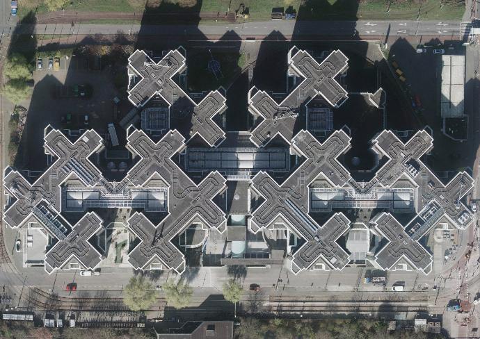
Eurosense has built a strong reputation in the acquisition of aerial imagery and LiDAR measurements. On top of that, Eurosense also produces other value-added products such as land cover classifications, 3D city models, object detection maps, and so on. Thermography and tree health assessments are other important focus areas of Eurosense. Eurosense works with both aerial and satellite imagery.
PRODUCTS
Eurosense acquires geo data from scratch with its company-owned fleet of aircraft, and state-of-the-art sensors (photogrammetric cameras, LiDAR scanners and thermographic cameras) . With the latest software and own hardware, the team of skilled engineers and operators process this raw geo data into useful, value-added products.
EQUIPMENT
Eurosense was founded in 1964, and is proud to build on its rich history and experiences.
Throughout the years and decades, Eurosense has always been at the forefront of innovation, research and development.
HISTORY
COUNTRIES WITH
LOCAL OFFICES
YEARS OF EXPERIENCE
KM2 COVERED
The RTBF (Belgian Radio-Television of the French Community) wrote an interesting article about imagery acquired by us during the lockdown in Belgium in April 2020. Have a look at the images of Pairi Daiza, Walibi or Durbuy and the comparison with imagery of previous years.
As Eurosense has been in business since 56 years, we dispose of a huge archive of aerial imagery. Time series can be created by focusing on the same place, and indicate the landscape and city evolutions. The examples here all come from Slovakia, where Eurosense offers country-wide off-the-shelf data, captured during the last 3 years.
Eurosense has been awarded the correction and optimization of the roof geometry for the 3D City Model of Antwerp. A few special buildings will also be modeled more in detail. Previously Eurosense already developed a 3D city model of Antwerp, and with this new project we are going one more step in the direction of a digital twin. The optimized 3D model will be used for city-wide and local research, as well as external studies. Examples include green roof potential, water storage capacity, air pollution simulations, etc. A 3D-print of (parts of) the city will also be possible.
We are happy to help you!